Application Description
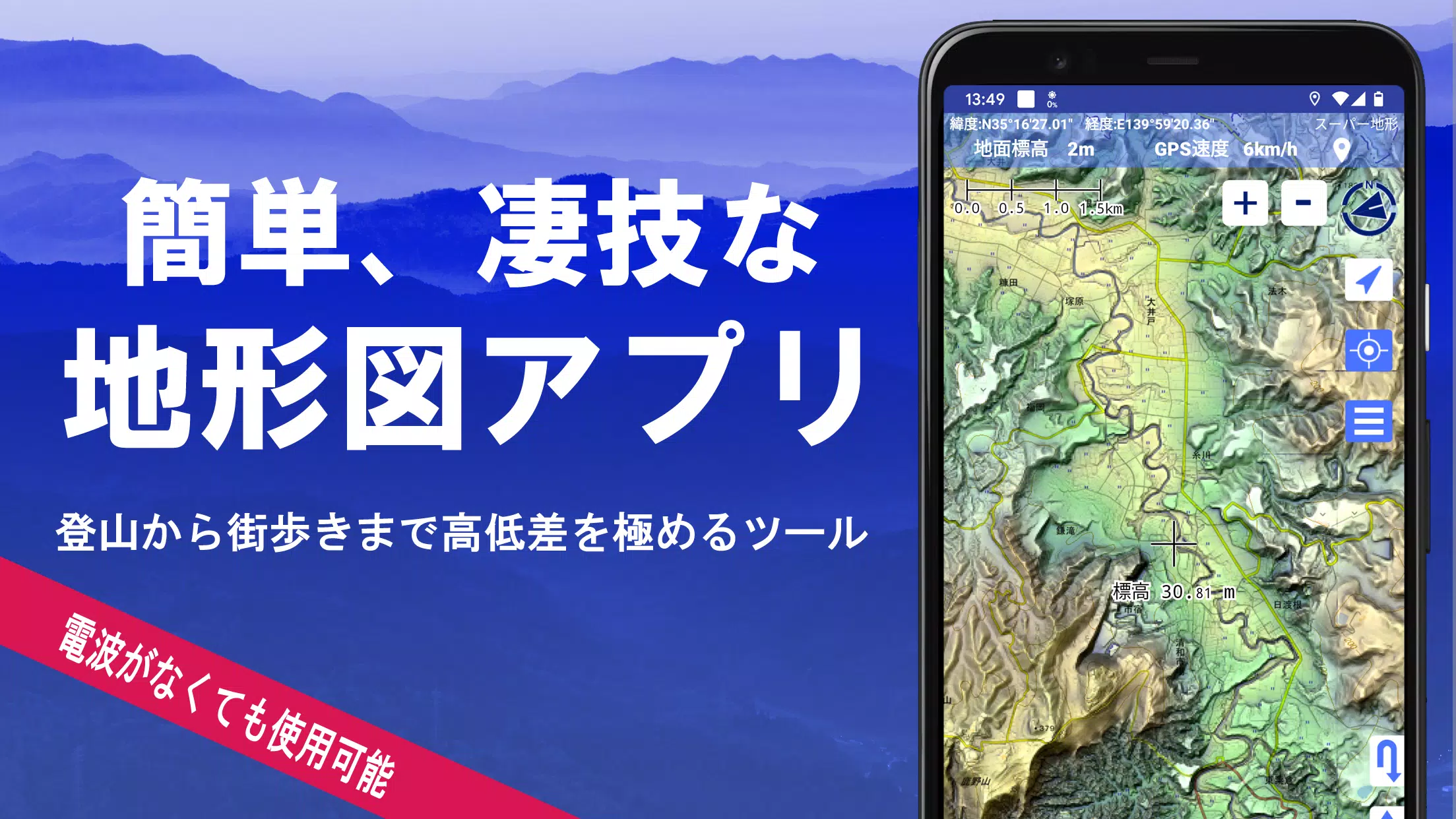
Discover the vast world of mapping with over 100 types of maps at your fingertips, including the esteemed Geographical Survey Institute map. Whether you're scaling mountain peaks or strolling through city streets, our app leverages these maps to highlight every elevation change, making your journey more engaging and informative.
Our commitment to excellence was recognized when we received the 2018 Japan Cartographic Society Award for Best Work. This accolade underscores our dedication to providing top-tier mapping solutions.
- Utilize our unique "super terrain data" technology to enhance your terrain experience.
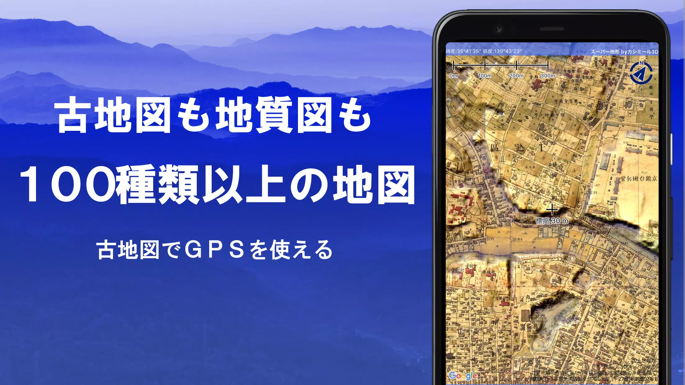
- Access an extensive range of maps from the Geospatial Information Authority of Japan, including topographic, geological, old, historical, and prewar Ordnance Survey Department maps.
- Record your journeys using the GPS function, with capabilities for GPX log input/output and editing.
- Benefit from features designed to support urban exploration, mountain climbing, and outdoor activities, including GPS navigation with audio, data recording, and editing.
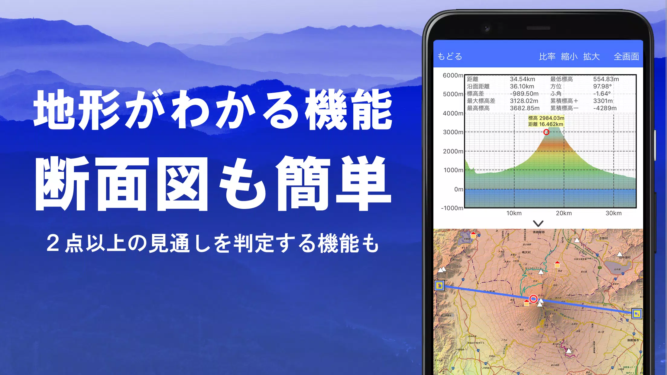
- Employ the visibility determination function for creating cross-sectional diagrams, aiding in observation, radio planning, and more, complete with building displays.
- Enjoy a 360° panoramic view function to identify mountains and track celestial bodies like the sun and moon, alongside GPS points.
- Ensure seamless offline usage with GPS functionality, bulk map downloads, and map caching, perfect for areas without radio signals.
- Link photos to specific points on your map.
- View contour lines derived from elevation data.
- Display MGRS grids (UTM grids).
- Read, display, and edit GIS data from GeoJSON files.
- Create and draw shapes.
- Use the app internationally.
- Print maps or output them as PDFs.
- Experience the convenience of a dark theme.
1. A Wealth of Maps at Your Disposal
Our collection boasts over 100 types of maps, including combinations of our super topographic data, maps from the Geospatial Information Authority of Japan, and hazard maps. Note that availability of aerial photographs may vary by age group, with "latest" and "around 1974" offering broader coverage. Enjoy a 5-day free trial of maps using super terrain data post-installation.
2. Cross-Section and Outlook Creation
Effortlessly draw cross-sections through any point on the map. Our app also includes the renowned visibility judgment function from Kashmir 3D, factoring in Earth's curvature and atmospheric variations. It's ideal for route planning during mountain climbs, assessing wireless visibility, and understanding terrain. Where PLATEAU building data is available, you can include buildings in your cross-sectional views.
3. Elevation Palette Function
Customize your map's background color with the elevation palette function, adjusting it to your preferred gradient in 1cm increments.
4. Panoramic View
Experience panoramic observation maps that reveal mountain names from any location. Our 360° panorama integrates with your smartphone's compass, perfect for mountain identification. View the sun and moon, including moon phases, to explore phenomena like Diamond Fuji and Pearl Fuji. Additionally, display GPS points and create panoramic views of overseas mountains.
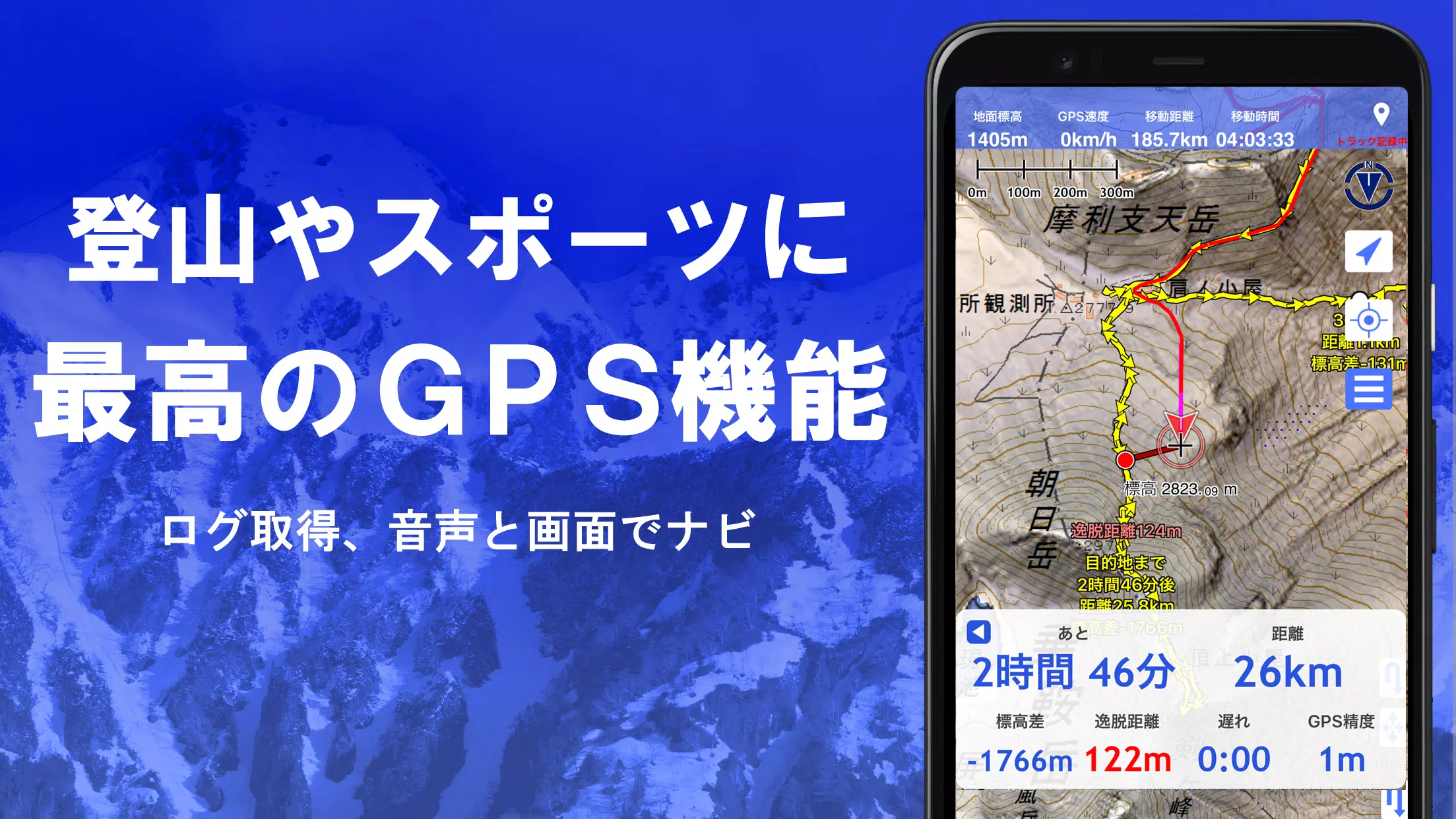
5. GPS Function
Leverage your smartphone's GPS to obtain location data and record tracks. Our high-precision positioning is designed for rigorous mountain climbing and outdoor activities. Visualize your recorded tracks with parameters like elevation change, speed, time, and elapsed time. The point alarm function alerts you with voice and sound as you approach designated points. Display photos linked to specific points and send the map center position to NaviCon.
6. GPS Track Summary Playback
Replay your track logs comprehensively. The app automatically matches and displays photos from your smartphone based on their capture times, with icons marking photo locations for easy access.
7. GPS Navigation Function
Navigate along preset tracks with the Track Navi feature, receiving voice or alarm alerts if you stray off course. This ensures you won't lose your way during climbs. Additionally, utilize route navigation for urban walks and point navigation to reach specific locations.
8. GPS Data Editing Function
Manage GPS-related point, route, and track data, organized in folders and displayed in an easy-to-read tree format. Create tracks directly on the map and import/export in GPX format from mountain climbing sites.
9. Map Usage Outside the Service Area (Offline)
Continue using maps in areas without signals, such as during mountain climbs, thanks to our bulk download function that ensures all scale maps of specified plots are available. A cache function further enhances offline usability.
10. Map History Function
The app remembers your viewed locations, allowing you to revisit them easily.
11. Custom Map Compatibility
Import and use custom maps created with Kashmir 3D's map cutter, including your own or scanned maps. When using the map cutter, divide images into approximately 256 x 256 segments and send the resulting kmz file to Super Terrain via email or Cloud Drive.
12. GeoJSON Compatibility
Display and edit points, linestrings, and polygons from GeoJSON files, and draw new shapes.
13. Print/PDF Output
Print any map area at a specified scale or generate a PDF.
14. Integration with Other Apps
Input and output GPS data in GPX, KML, and GDB formats, facilitating data exchange with other apps, Kashmir 3D on your PC, and mountain climbing sites.
15. Backup Function
Backup all app data (excluding cached maps) and remove it from your smartphone. Restore data even if you delete the app or face device issues. An automatic backup feature using Google Drive ensures your data is always up-to-date. Refer to the manual for detailed instructions.
16. Billing Function
Certain features, such as maps using super terrain data, GPS track functions, and cross-sectional views, require in-app purchases. Post-purchase, the number of search results for place name searches increases.
- Fees: Annual payment of 780 yen/year.
- Free Trial: Enjoy a 5-day free trial upon first installation. After 5 days, some features and maps will be unavailable unless you purchase them. No charges will be applied without your explicit purchase action. To purchase, navigate to [Settings] - [Purchase to remove functional restrictions] within the app.
- Confirmation and Cancellation: Check or cancel automatic updates via Google Play by selecting "Regular Purchase" from the menu and then "Super Terrain".
- Price Revision: Prices may change with future enhancements, making early purchase advantageous.
17. Terms of Use
The copyright holder and developer are not responsible for the outcomes of using this application. Upon first use of GPS, you'll be prompted to allow location services. Continuous GPS use can drain your battery, so if your device is used for emergency communication, carry a spare battery. For a detailed explanation of the navigation function, refer to the PDF at https://www.kashmir3d.com/online/superdemapp/superdem_navi.pdf. Note that some smartphones may interrupt or fail to record tracks due to power-saving features that close background apps, a common issue across various apps. Turning off the screen while using Super Terrain may temporarily maintain recording, but this isn't a permanent solution.
Screenshot
Reviews
Apps like スーパー地形 - GPS対応地形図アプリ


Trending apps


Top News


Latest Apps


Latest Articles