Japanese Gov Releases Free Minecraft Tokyo Underground Map
The Japanese government has released a Minecraft map of the world's largest underground flood diversion facility. It's available for free download, allowing you to explore one of the Tokyo area's remarkable engineering achievements from your own home.
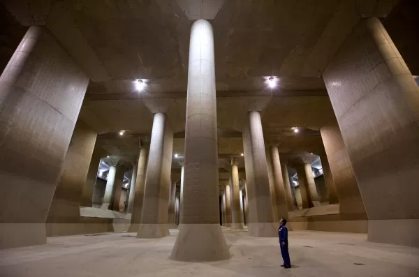
Officially named the Metropolitan Area Outer Underground Discharge Channel and commonly called G-Cans, this facility is a critical piece of infrastructure for disaster prevention. Its most famous section is the "pressure adjustment tank," a colossal underground chamber supported by 59 massive pillars. This awe-inspiring space, often likened to an underground temple (chika shinden) in Japan, has a dramatic, almost cinematic quality. Its unique atmosphere has made it a popular filming location for music videos, Japanese TV dramas such as Kamen Rider, and movies.
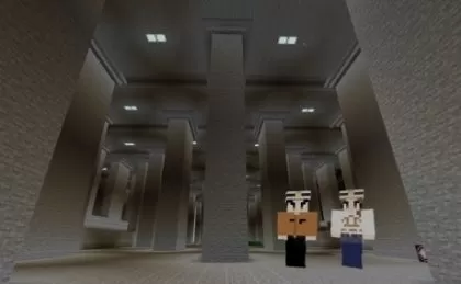
While guided tours of G-Cans are available during dry periods, the Japanese Ministry of Land, Infrastructure, Transport and Tourism (MLIT) now offers a virtual alternative through Minecraft. The ministry has published a video on its official YouTube channel explaining the purpose of G-Cans and providing a glimpse of its blocky Minecraft counterpart.
The free Minecraft map includes more than just the underground facility. It also features an above-ground area with rivers, houses, and neighborhoods, helping players understand how G-Cans protects communities from flooding. You can even enter the control room and simulate the process of draining floodwater into the facility's shafts to see how the system operates.
MLIT created this Minecraft replica to educate the public about the facility's vital role in disaster prevention. Exploring the virtual model gives a powerful sense of the structure's immense scale. In reality, G-Cans consists of over 6 kilometers of concrete tunnels running beneath Saitama Prefecture in the Greater Tokyo Area. Its five large shafts collect water from rivers prone to overflowing during Japan's rainy season in June and the typhoon season, typically around September. This water is then gradually released into the larger Edogawa River and Tokyo Bay. Completed in 2006 after more than a decade of construction, G-Cans has been instrumental in mitigating flood damage in the region.
The G-Cans Minecraft map is available for free download from the official website of the Edogawa River Office, the body responsible for managing the facility. You will need at least Minecraft Bedrock Edition version 1.21.1 or Minecraft Education Edition version 1.21.0 to use the map.
Latest Articles
Trending Games


![Taffy Tales [v1.07.3a]](https://imgs.anofc.com/uploads/32/1719554710667e529623764.jpg)


Top News

Latest Games